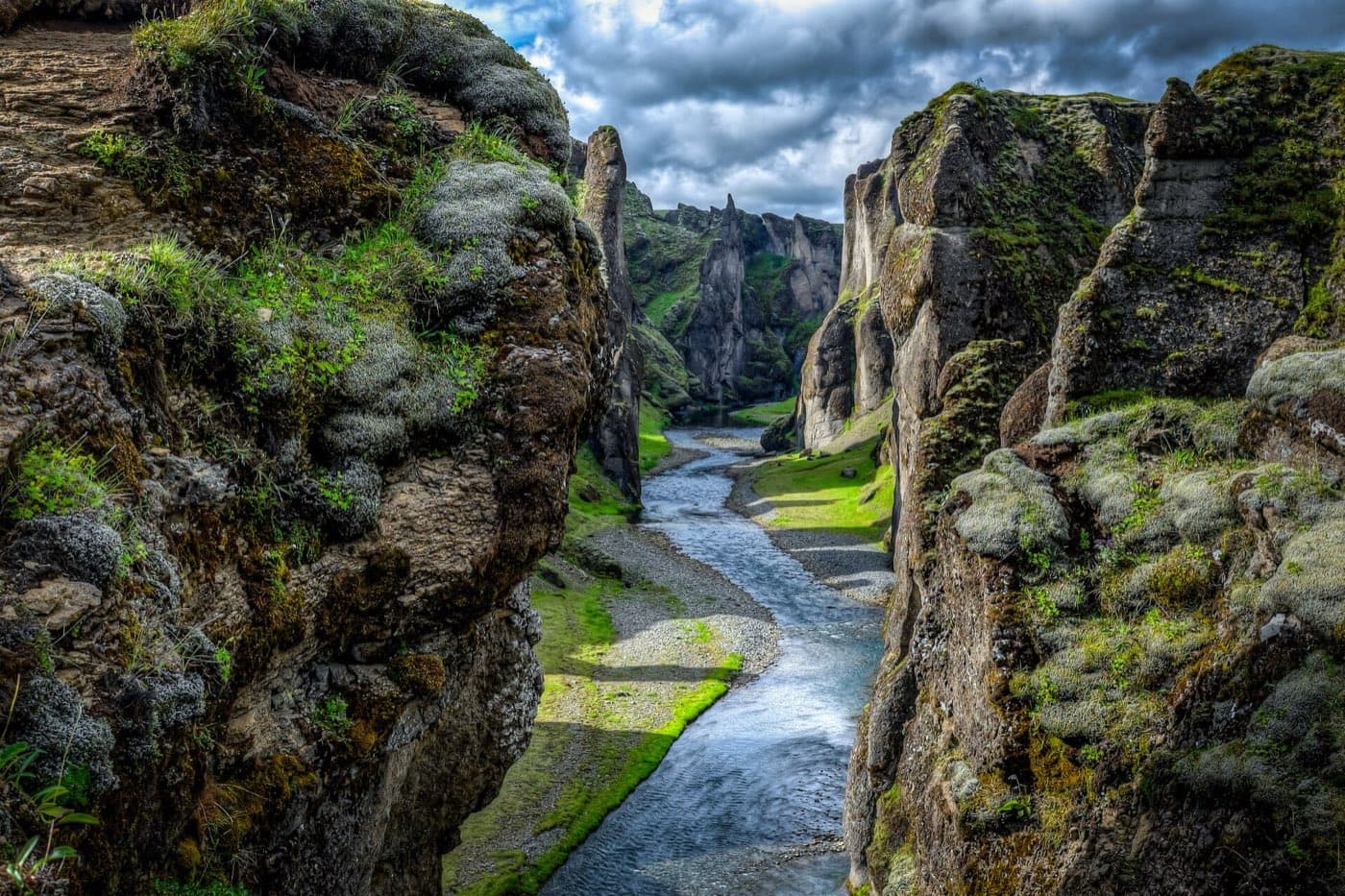
Fjaðrárgljúfur is a river canyon in southeast Iceland, around 2 kilometres long, with the Fjaðrá river running along its floor. It sits near the village of Kirkjubæjarklaustur, just off Route 1, the Ring Road, and a marked path along the rim leads to a series of viewpoints. The site is protected, and the Environment Agency of Iceland closes it at times, especially in spring, to let the ground recover.
Fjaðrárgljúfur at a glance
| Feature | Detail |
|---|---|
| Meaning | "Feather river canyon" |
| Location | Near Kirkjubæjarklaustur, southeast Iceland |
| River | Fjaðrá |
| Length | About 2 km |
| Access | Marked rim path and viewpoints, off Route 1 |
Where Fjaðrárgljúfur is
The canyon lies in southeast Iceland near Kirkjubæjarklaustur, a short turn off Route 1, the Ring Road. That puts it well east of the main South Coast waterfalls and roughly between them and the glacier country around Vatnajökull, so it is often a stop on a longer trip east rather than a destination on its own. A gravel road leads from the Ring Road to a car park at the lower end of the canyon, where the rim path begins.
The canyon itself
Fjaðrárgljúfur is about 2 kilometres long, with steep, winding walls that fold back on each other above the river. The Fjaðrá river runs along the bottom, and the rock is palagonite, a soft volcanic material that erosion has shaped into the sharp ridges and pinnacles the canyon is known for. From the rim you look down and along the twisting gorge rather than into a single straight drop, which is why the viewpoints are spread out along its length.
How it formed
The canyon is younger than its rock. The bedrock is thought to be about two million years old, but the gorge itself was carved largely by glacial meltwater and was mostly cut by the end of the last Ice Age, roughly 9,000 years ago. As glaciers retreated, rivers fed by the melting ice dug down through the palagonite over a long stretch of time, deepening the channel into the winding form seen today. The Fjaðrá continues that slow work now, though far more gently than the glacial floods that first shaped it.
The viewing path
A marked footpath runs along the top of the canyon to a series of viewing platforms, each looking down on a different bend of the gorge. Rope barriers and signs keep people on the route, which matters because the vegetation and soil at the edge are fragile and slow to recover once trampled. The walk is not long, but the ground can be uneven and slippery in wet weather, so shoes with grip help. Staying on the path protects both the site and you, since the drops are steep and unfenced beyond the marked edges.
Seasonal closures and protection
Fjaðrárgljúfur drew far more visitors after it appeared in Justin Bieber's 2015 music video "I'll Show You," and the extra foot traffic damaged the ground where people left the paths. In response, the Environment Agency of Iceland now manages it as a conservation area and has closed it to visitors at times to let the vegetation recover, with reopening around 1 June after spring closures. Short seasonal closures can still happen in spring, roughly March to May, when snowmelt leaves the ground soft, so check the current status before you go.
Visiting Fjaðrárgljúfur
Because it is far east on the South Coast, most people reach the canyon as part of a longer drive or a multi-day trip rather than a day out from Reykjavík. It pairs naturally with the sights around Kirkjubæjarklaustur and the glacier areas further east. Some guided South Coast and Ring Road trips include it, which takes the driving and the timing off your plate. To compare organised options, look at South Coast tours that stop at Fjaðrárgljúfur before you travel.
Allow time for the road
Check the Driving Distance Calculator when deciding how Fjaðrárgljúfur canyon belongs in the rest of your itinerary.