Iceland's canyons range from a 2 km serpentine gorge in the south to a 7.7 km rift valley at Thingvellir. Canyons in Iceland include Fjadrargljufur, Studlagil, Asbyrgi, Sigoldugljufur, Bruarhlod, and Almannagja, each shaped by a different process. Some sit in the highlands on seasonal roads, while others stay on lowland paved roads.
How Iceland's canyons were carved
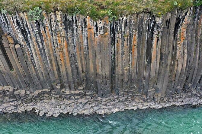
Iceland's canyons are carved by three forces: glacial rivers, catastrophic glacial floods called jokulhlaups, and the slow pull of tectonic plates. Many canyon walls are made of palagonite and hyaloclastite, rock that forms when lava erupts under ice or water and cools quickly. Basalt columns form through a process called columnar jointing, when thick basaltic lava cools slowly, shrinks in volume, and cracks into hexagonal shapes. Thick green moss covers many canyon walls in summer, creating a contrast against the dark rock.
The most spectacular canyons across the regions
Fjadrargljufur is a narrow, serpentine canyon in South Iceland near Kirkjubaejarklaustur. The canyon is about 2 km long, and the Fjadra river flows along its floor. Fjadrargljufur was carved into palagonite rock about 9000 years ago at the end of the last Ice Age. The bedrock in Fjadrargljufur is thought to be about 2 million years old.
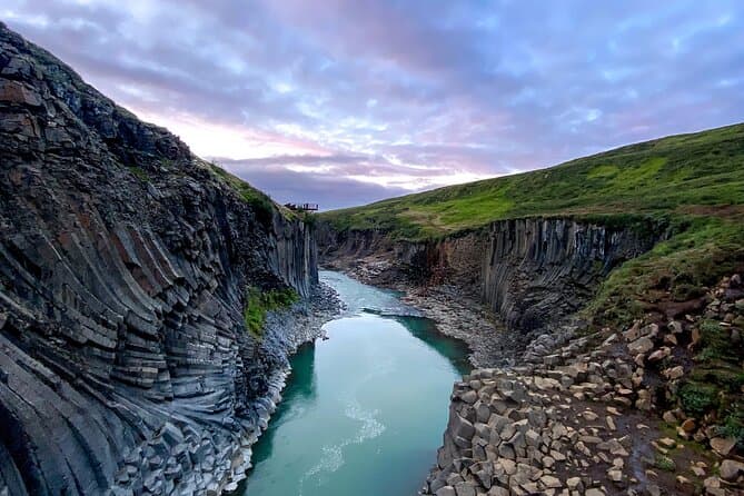
Studlagil is a basalt column canyon in the Jokuldalur valley in East Iceland, known for its hexagonal basalt columns and a turquoise river. Studlagil holds one of Iceland's largest collections of basalt rock columns, shaped by the Jokla river, also called Jokulsa a Dal.
Asbyrgi is a horseshoe-shaped glacial canyon in North Iceland within Vatnajokull National Park. It lies about 38 kilometers east of Husavik on the Diamond Circle route and is about 3.5 km long and over 1 km wide. The cliffs of Asbyrgi reach up to 100 meters high, and a rock formation called Eyjan, up to 25 meters high, divides much of Asbyrgi down the middle. Asbyrgi was formed by catastrophic glacial floods from the Jokulsa a Fjollum river, one about 8000 to 10000 years ago and another about 3000 years ago. Birch and willow woodland grows inside Asbyrgi.
Bruarhlod is a small canyon on the Hvita river in the Golden Circle area, about 20 meters deep. The Hvita river originates from the Langjokull glacier and carries fine glacial sediment that colours the water.
Almannagja is a rift gorge in Thingvellir National Park where the North American and Eurasian tectonic plates pull apart along the Mid-Atlantic Ridge. Iceland is the only place where this Mid-Atlantic Ridge rift sits above sea level. Almannagja is about 7.7 km long and up to 40 meters deep, and the tectonic plates at Thingvellir drift apart by about 2 cm per year.
Hidden canyons revealed by hydropower and folklore
Sigoldugljufur, nicknamed the Valley of Tears, is a canyon in the central Highlands near the road to Landmannalaugar. Dozens of thin waterfalls, 50 or more depending on season and rainfall, stream down the mossy eastern wall of Sigoldugljufur into turquoise water. These waterfalls were revealed when the Sigalda hydroelectric station was built in the 1970s and lowered river levels. A walk of about 1 km on easy terrain leads to the Sigoldugljufur viewpoint.
Studlagil canyon became visible after the flow of the Jokla river was reduced by the Karahnjukar hydropower plant, roughly between 2006 and 2009. Studlagil was largely unknown until an Icelandic photographer popularized it around 2016.
Icelandic folklore says Asbyrgi is a hoofprint left by Odin's eight-legged horse Sleipnir.
The name Almannagja means Everyman's Gorge, and Iceland's Althingi parliament was founded nearby in the year 930.
When to visit and how to reach the canyons safely
Highland roads to canyons such as Sigoldugljufur typically open between mid-June and early July and close in September or October. A 4x4 vehicle is needed to reach highland canyons on gravel highland roads in summer. Lowland canyons such as Fjadrargljufur, Bruarhlod and Almannagja are reachable on paved roads for much of the year, while highland canyons are seasonal. Use the Road Conditions to help plan your trip.
Comparing guided canyon tours and self-drive routes
You can compare East Iceland tours to see the current options.